Resources · Acreages by town
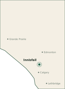
Growing zones near Innisfail: Innisfail (zone 3b) · Red Deer (zone 3b) · Olds (zone 3b) · Alberta growing zones map
Acreages Near Innisfail, Alberta: What the Land Is Like
Innisfail is a working-farm town on the Highway 2 corridor with acreages carved from quarter sections rather than subdivisions. Soils are good, wells are moderate, and the Red Deer River valley east of town adds slope and flood limits.
The figures below are regional context for Red Deer County, the municipality that administers rural land around Innisfail. They are a starting point for reading listings within roughly 15 km of town. They are not a survey of any parcel; a free land report built on the boundary you draw replaces every one of them with data for that quarter.
Water and wells around Innisfail
Nearby well records for Red Deer County point to completed wells around 33 m deep, with static water levels often in the 8–23 m range. The predominant aquifer on file is Paskapoo and Belly River bedrock. These figures come from a Land Intelligence report run on a representative quarter in the county (NW 23-38-27-W4; 299 provincial well records within 5 km), not from your parcel.
The Red Deer River cuts a deep valley through the county. Valley-edge lots can be closer to alluvial water; upland farm wells more often sit in bedrock. Do not copy a valley well log onto a bench parcel.
Before you make an offer, pull the well ID and the last pump test for the parcel, then look the neighbours up in the provincial database: see how to look up Alberta well records. If there is no well, budget for one with the cost to drill a well in Alberta page, and confirm the septic side with septic system cost in Alberta.
Growing season and hardiness zone
Red Deer County is generally treated as hardiness zone 3b, with a frost-free window on the order of 120 days. The zone is read from the Natural Resources Canada plant hardiness map (4th edition, 1991–2020 normals) at a representative quarter; frost dates are a regional table keyed by zone, not a logger on your fence.
City of Red Deer listings sometimes read warmer than the surrounding county. Use the colder of the two labels when you buy trees.
Solar on an acreage near Innisfail
Regional irradiance for this belt is about 6.2 kWh/m²/day in high summer and about 0.9 kWh/m²/day in mid-winter. Central Alberta gets usable summer sun. The river valley’s west walls lose afternoon light early — walk the site in December before you commit roof real estate.
Wetlands, flood areas, and the rules
Wetland density in Red Deer County is best described as moderate. Notable mapped or commonly discussed flood-hazard areas include Red Deer River valley, Blindman River.
Parkland sloughs and tributaries of the Red Deer River mean many quarters have a wetland to work around. Whether one is regulated depends on how often it holds water and how it connects to the wider landscape.
Draining, filling, or ditching a wet area needs approval under the Water Act even when it looks like a low spot in a field. Read how to check for regulated wetlands before you plan a shop pad or a garden on the wet corner.
The rest of the acreage checklist
- 15 questions to ask before buying an acreage in Alberta
- How to search Alberta land titles for rights-of-way, easements, and caveats
- Subdividing land in Alberta if you plan to split a parcel later
- Alberta contractors for wells, septic, solar, fencing, and driveways
- Grant eligibility quiz for farm and land programs that may apply
See the parcel, not the county
County figures tell you whether a listing near Innisfail is in the right universe. The free land report tells you about the quarter itself: nearby well records, terrain and drainage, mapped wetlands and flood status, hardiness and frost, solar, tree cover, and species observed nearby.
Generate a free land report for a property near Innisfail →
Sampled from the live report pipeline at a representative quarter in Township 38, Range 27, W4 on 2026-10-08: well depth, hardiness zone, solar irradiance (299 well records within 5 km). Text reviewed 2026-10-08. Methodology.
Also for this county
- Acreages near Innisfail
- Acreages near Red Deer
- Acreages near Sylvan Lake
- Well drillers serving Red Deer County
- Septic installers serving Red Deer County
- Solar installers serving Red Deer County
- Fencing contractors serving Red Deer County
- Excavation contractors serving Red Deer County
- Search all providers serving Red Deer County
- Read a real report (Crown land, Strathcona County)
- Alberta Resource Economics Atlas: subsurface geology, mines and mineral projects
- Alberta grant program guide and dates calendar